Taal Crater
Philippines /
Southern Tagalog /
Laurel /
World
/ Philippines
/ Southern Tagalog
/ Laurel
World / Philippines / Batangas / Taal lake
crater lake
Add category
Taal Volcano is an active volcano on the island of Luzon in the Philippines. It consists of an island in Lake Taal, which is situated within a caldera formed by an earlier very large eruption. It is about 50 km from the capital, Manila.
The volcano has erupted violently several times, causing loss of life in the populated areas surrounding the lake. Due to its eruptive history and location close to population centres, the volcano has been designated a Decade Volcano worthy of close study to prevent future natural disasters.
Taal Volcano is part of a chain of volcanoes along the western side of the island of Luzon, all formed by the subduction of the Eurasian Plate underneath the Philippine Plate. Taal Lake lies within a 25–30 km caldera formed in four giant explosive eruptions between 500,000 and 100,000 years ago. Each of these eruptions created extensive ignimbrite deposits, reaching as far away as where Manila stands today.
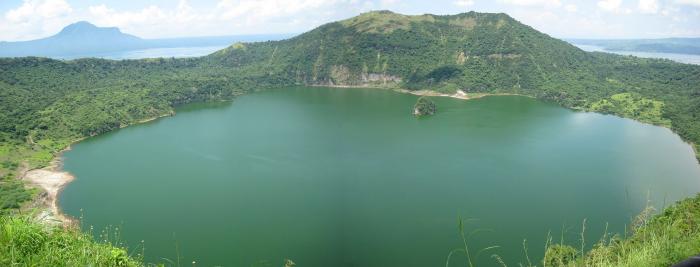
Since the caldera formation, subsequent eruptions have built up the current Taal Volcano, on an island known as Volcano Island in the lake. This island covers an area of about 23 km², and is made up of overlapping cones and craters from many different eruption episodes. 47 cones and craters have been identified on the island. Volcano island contains a lake about 2km across, called Crater Lake, within which is another island.
here have been 33 recorded eruptions at Taal since 1572. A very devastating eruption occurred in 1911, which claimed more than a thousand lives. In the writer's view, the eruption was the result of the intrusion of a hydrothermal system by magma, resulting in a major phreatic eruption. The deposits of that eruption is yellowish, fairly decomposed (non-juvenile) tephra with a high sulfur content (<3%).
The most recent period of activity lasted from 1965 to 1977, and was characterised by the interaction of magma with lake water, producing violent phreatic explosions. In particular, the 1965 eruption led to the recognition of base surge as a common process in volcanic eruption (due to the fact that one of the American geologists, who visited the volcano shortly after the 1965 eruption, had to witness an atomic bomb explosion when he was a soldier). The eruption generated base surges and cold pyroclastic flows, which travelled several kilometres across Lake Taal and devasted villages on the lake shore, killing some hundred people. The population of the island itself was evacuated only after the onset of the eruption. Precursory signs were interpreted correctly only after the eruption. Eruptions in 1968 and 1969 were characterized partly by strombolian activity and produced a major lava flow that reached the shore of lake Taal. The 1977 produced only a very minor cider cone within the main crater.
Although the volcano has been dormant since 1977, it has shown signs of unrest since 1991, with strong seismic activity and ground fracturing events, as well as the formation of small mud geysers on parts of the island.
The volcano has erupted violently several times, causing loss of life in the populated areas surrounding the lake. Due to its eruptive history and location close to population centres, the volcano has been designated a Decade Volcano worthy of close study to prevent future natural disasters.
Taal Volcano is part of a chain of volcanoes along the western side of the island of Luzon, all formed by the subduction of the Eurasian Plate underneath the Philippine Plate. Taal Lake lies within a 25–30 km caldera formed in four giant explosive eruptions between 500,000 and 100,000 years ago. Each of these eruptions created extensive ignimbrite deposits, reaching as far away as where Manila stands today.
Since the caldera formation, subsequent eruptions have built up the current Taal Volcano, on an island known as Volcano Island in the lake. This island covers an area of about 23 km², and is made up of overlapping cones and craters from many different eruption episodes. 47 cones and craters have been identified on the island. Volcano island contains a lake about 2km across, called Crater Lake, within which is another island.
here have been 33 recorded eruptions at Taal since 1572. A very devastating eruption occurred in 1911, which claimed more than a thousand lives. In the writer's view, the eruption was the result of the intrusion of a hydrothermal system by magma, resulting in a major phreatic eruption. The deposits of that eruption is yellowish, fairly decomposed (non-juvenile) tephra with a high sulfur content (<3%).
The most recent period of activity lasted from 1965 to 1977, and was characterised by the interaction of magma with lake water, producing violent phreatic explosions. In particular, the 1965 eruption led to the recognition of base surge as a common process in volcanic eruption (due to the fact that one of the American geologists, who visited the volcano shortly after the 1965 eruption, had to witness an atomic bomb explosion when he was a soldier). The eruption generated base surges and cold pyroclastic flows, which travelled several kilometres across Lake Taal and devasted villages on the lake shore, killing some hundred people. The population of the island itself was evacuated only after the onset of the eruption. Precursory signs were interpreted correctly only after the eruption. Eruptions in 1968 and 1969 were characterized partly by strombolian activity and produced a major lava flow that reached the shore of lake Taal. The 1977 produced only a very minor cider cone within the main crater.
Although the volcano has been dormant since 1977, it has shown signs of unrest since 1991, with strong seismic activity and ground fracturing events, as well as the formation of small mud geysers on parts of the island.
Wikipedia article: http://en.wikipedia.org/wiki/Taal_Lake
Nearby cities:
Coordinates: 14°0'36"N 120°59'51"E
- Lake Taal 11 km
- Lake Toba 2763 km
- Lake Chŏnji 3192 km
- Lake Dakataua 3844 km
- Kurile Lake 5268 km
- Hal The collection Meteorites Craters (Meteor Craters Area) 6707 km
- Lake Nemrut ( Sarakn ) 8086 km
- Öskjuvatn 10553 km
- clearwater crater chain 11996 km
- clearwater crater chain 12015 km
- Taal Volcano 0.5 km
- Lake Taal 3.4 km
- Binintiang Malaki Volcano 4.1 km
- Lambauing Island 4.3 km
- Banyaga Barangay Proper 5.4 km
- Club Balai Isabel 9 km
- Palm Ridge Pointe 9 km
- Lauena de Taal 10 km
- Tagaytay Ridge 12 km
- Cavite 35 km
Comments