Kalayaan
Philippines /
Southern Tagalog /
Taburi /
World
/ Philippines
/ Southern Tagalog
/ Taburi
World
reef, draw only border, third-level administrative division

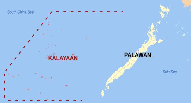

Kalayaan, officially the Municipality of Kalayaan (Tagalog: Bayan ng Kalayaan), is a 6th class municipality in the South China Sea under the jurisdiction of the province of Palawan, Philippines. According to the 2020 census, it has a population of 193 people.
Part of the Spratly Islands, situated within the South China Sea, the Kalayaan municipality, which includes Thitu Island (locally known as Pag-asa, the administrative center of Kalayaan Island Group) is 280 nautical miles north-west of Puerto Princesa and 932 kilometres (579 mi) south-west of Metro Manila. It consists of a single barangay located on Pag-asa Island, which also serves as the seat of the municipal government. It is the least populated municipality in the Philippines. Kalayaan's annual budget is 47 million pesos (about $1.1 million).
Kalayaan municipality has an airstrip, a naval port, a five-bed lying-in clinic, a police station, a coast guard station, a marine research station, and a small elementary school.
Formerly an exclusively military installation, Pag-asa Island was opened to civilian settlement in 2002.
Kalayaan has the highest poverty incidence and is one of the poorest municipalities in the Philippines.
Wikipedia article: http://en.wikipedia.org/wiki/Kalayaan,_Palawan
Nearby cities:
Coordinates: 11°3'27"N 114°17'6"E
- Rizal 387 km
- Bataraza 404 km
- Quezon 416 km
- San Vicente 509 km
- Roxas 526 km
- Taytay 538 km
- Cuyo 689 km
- Cagayancillo 718 km
- Pangutaran 779 km
- Pandami 870 km
- Loaita Bank 34 km
- Tizard Bank 88 km
- Benitez Reef 119 km
- Discovery Great Reef 121 km
- Union Bank and Reefs 135 km
- Fiery Cross Reef 216 km
- Alison Reef 253 km
- Cornwallis South Reef 261 km
- Cay Marino 285 km
- East London Reef 309 km