

Explained | The Fujiwhara Effect: What happens when two powerful storms collide?

Story highlights
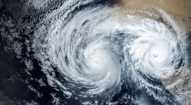
This phenomenon, where two cyclones interact, is known as the Fujiwhara effect. For the Fujiwhara effect to take place, the eyes or centres of both storms should be at a distance of less than 1400 km from each other.
Two storms whirling off the southeastern coast of the US have raised concerns among observers. On one hand, Hurricane Idalia is crawling towards Florida’s Gulf Coast; on the other, Hurricane Franklin is spinning around Bermuda.
It must be noted that these two hurricanes are brewing in close vicinity; however, they are not expected to cross paths. But the news of both storms emerging at the same time has triggered concerns—what might happen if the two storms collide?
The Fujiwhara Effect
According to the National Weather Service (NWS), when two hurricanes (or cyclones, depending on your location) rotate in the same direction and come close to each other, they engage in an intense ‘rotational dance’ around a shared centre.
This phenomenon, where two cyclones interact, is known as the Fujiwhara effect. For the Fujiwhara effect to take place, the eyes or centres of both storms should be at a distance of less than 1400 km from each other.
Sakuhei Fujiwhara, a Japanese meteorologist, identified this phenomenon, which was first described in a paper published in 1921. Many years later, the occurrence was observed in the western Pacific Ocean when typhoons Marie and Kathy merged in 1964.
Five Possibilities under Fujiwhara Effect
First possibility: If one hurricane is stronger than the other, the smaller one will orbit around the larger one and eventually collide with its centre, leading to absorption.
Second possibility: If two storms of almost equal strength pass near each other, they might be drawn towards a shared centre, potentially merging or simply swirling around each other temporarily before following separate paths.
Third possibility: In rare cases, if the two cyclones are sufficiently powerful, they can combine, resulting in the formation of a supercyclone capable of causing significant destruction along coastlines.
Fourth possibility: Partial straining out happens, in which a part of the smaller storm is lost to the atmosphere.
Fifth possibility: Complete straining out takes place, in which the smaller storm is completely lost to the atmosphere. The straining out does not happen for storms of equal strength.
Will Idalia and Franklin collide?
On Monday (August 28), Idalia was gaining strength as it moved northward, following a projected path that would take it across the Gulf of Mexico towards Florida's western coast.
As it neared Cuba, it brought sustained winds of 70 mph (112k/h), but meteorologists expected it to intensify into a Category 3 hurricane before reaching Florida. Certain areas of Florida were under hurricane warnings, with Idalia expected to make landfall on Wednesday (August 30).
Governor Ron DeSantis of Florida warned during a press briefing on Monday about the significant impact likely from the storm, urging Floridians to take necessary precautions.
On the flip side, Franklin was positioned farther to the east, situated over the Atlantic Ocean. While landfall wasn't predicted, the storm's trajectory was forecasted to continue northward, running parallel to the US east coast.
Watch: Hurricane Hilary reduced from category 4 to category 2 storm
The National Hurricane Center issued alerts for potential tropical storm conditions in Bermuda from Franklin on Wednesday, highlighting the chance of "life-threatening surf" and strong rip currents along the US coastline in the coming days.
After crossing Florida, Idalia was expected to hug the southeastern coastline of Georgia and the Carolinas on Thursday, before moving into the Atlantic by Friday. Franklin's projected path would place it above Idalia's anticipated position on Thursday.
But there is a remote possibility that the two storms will ever meet.
Why Fujiwhara Effect is dangerous?
The occurrence of the Fujiwhara Effect induces greater unpredictability in cyclones due to their rapid intensification, increased rainfall, and novel patterns of movement over warming oceans. This complexity arises from the distinct nature of interactions between two storm systems.
In 2009, when Typhoons Parma and Melor emerged, the Fujiwhara Effect created significant challenges for meteorologists attempting to predict the trajectories and strengths of these storms.
This interaction led to widespread devastation in the Philippines, as the weaker Typhoon Parma unexpectedly gained strength, altered its path, and lingered over the Luzon region due to its interaction with the more powerful Typhoon Melor. Research published in the journal Weather and Climate Extremes in September 2020 documented that the typhoon exhibited multiple U-turns and made three landfalls over Luzon.
In April 2021, a similar incident occurred in the Indian Ocean, as Cyclone Seroja and Cyclone Odette interacted just off the coast of Western Australia. This interaction caused Seroja to intensify and adopt unprecedented trajectories.
Prior to this interaction, Seroja had already triggered flooding and landslides in Indonesia. Subsequently, Seroja maintained its strength and inflicted damage on 70 per cent of buildings in the small Australian resort town of Kalbarri.
Also, the lack of research and historical data about the Fujiwhara Effect makes things difficult for weather agencies and observers. Thus, evaluating Fujiwhara Effect instances over extended time frames still remains challenging.
)