

(CNN) — Hurricane Idalia is now thrashing much of northern Florida and south Georgia, whipping winds up to 90 mph, dumping heavy rain and hurling seawater into flooded cities as its impacts a 250-mile swath of the Southeast.
Several major bridges connecting islands to the mainland are now inaccessible as Idalia’s violent trek across Florida also threatens coastal Georgia and South Carolina with intense flooding, ferocious winds and tornadoes.
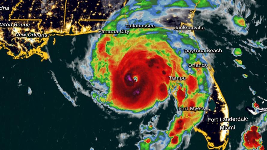
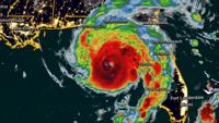
Idalia slammed Florida’s Big Bend area – the nook between the panhandle and peninsula – near Keaton Beach Wednesday morning at a dangerous Category 3 strength. That part of the Gulf Coast hasn’t seen such deadly storm surge and wind gust for at least 125 years.
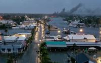
In the vulnerable island city of Cedar Key, a water level record was shattered amid 8 to 9 feet of storm surge. And the water was still rising fast – predicted to hurl seawater as high as halfway up the second floor of an average building.
Water levels on the Steinhatchee River in the Big Bend town of the same name rose more than 9 feet in about two hours Wednesday morning, reaching more than 8 feet higher than the normal highest tides and breaking – by a foot – the record set during Hurricane Hermine in 2016.
Swaths of Tampa, St. Petersburg and Fort Myers Beach also have been engulfed by wind-whipped seawater and torrential rain.
Then there’s the looming threat of a massive “king tide.” Officials in western Florida warned residents not to get a false sense of security as the hurricane slowly pulls away.
“We fear that residents will walk outside, see it’s sunny outside and think everything’s fine. But there’s more water coming,” warned Rob Herrin, spokesperson for Hillsborough County Fire Rescue. “There’s still so many hazards after the winds and rains have cleared.”
‘We’re effectively cut off from the world now’
Even before landfall, Cedar Key looked “almost apocalyptic,” resident Michael Bobbitt said early Wednesday. Hours later, the disastrous storm surge had overwhelmed it.
“We’re effectively cut off from the world now,” Bobbit said. “It’s going to get a lot worse, and I’m really fearful for what we’re going to find in some of the low-lying areas and some of our older, more infirm citizens today.”
Storm surge accounts for about half of all hurricane-related deaths, the National Oceanic and Atmospheric Administration said.
Meanwhile, a tornado watch is in place for nearly 12 million people across central and northern Florida and southeast Georgia until 3 p.m. Wednesday.
And destruction is possible far behind Idalia’s forecast cone, Florida Gov. Ron DeSantis said Wednesday morning. At least 11 tornado warnings already had been issued, with more possible – even in places “way outside the cone that you see on your TV screens,” he said.
Here are other developments around the state:
• Air travel halted: Hundreds of flights have been canceled as Tampa International Airport suspended commercial operations and St. Pete-Clearwater International Airport Terminal building closed Tuesday.
• Bridges are shut down: Major bridges connecting St. Petersburg to mainland Florida have been closed, according to online data from the Florida Department of Transportation. Road access to smaller barrier islands also is closed, Pinellas County Emergency Management said on X, formerly Twitter.
• Evacuations in at least 28 counties: Alachua, Baker, Citrus, Dixie, Franklin, Gilchrist, Gulf, Hamilton, Hernando, Hillsborough, Jefferson, Lafayette, Leon, Levy, Madison, Manatee, Marion, Nassau, Pasco, Pinellas, Putnam, Sarasota, Suwannee, Sumter, Taylor, Union, Volusia and Wakulla have all issued evacuation orders, some mandatory. An emergency declaration covers 49 of 67 Florida counties.
• Power knocked out: Nearly 270,000 homes, businesses and other power customers in Florida and nearly 40,000 in Georgia had no electricity around 11 a.m. Wednesday, according to PowerOutage.com.
• Thousands in shelters: Nearly 4,500 people are taking refuge in shelters in the impact area, Red Cross data Wednesday shows. The most people – 442 – were at a site in Largo, Florida, with more than 100 shelters open across the storm’s path, the aid group said.
• Officials prepare to respond: President Joe Biden will address the government response to the hurricane Wednesday afternoon, a White House official said. The Federal Emergency Management Agency has supplies and teams on standby, including urban search and rescue teams, to assist with the response as soon as the storm passes, the official said. At least eight urban search-and-rescue teams, 33 ambulance strike teams and 5,500 National Guard members are ready, and the Coast Guard is on standby, officials said Wednesday morning.
• Hospitals suspend services: Patients were being transferred from at least three hospitals: HCA Florida Pasadena Hospital, HCA Florida Trinity West Hospital and HCA Florida West Tampa Hospital. Meanwhile, Tampa General Hospital was constructing a water-impermeable barrier to remain open for emergency care.
• Schools and universities close: 50 county school districts have issued closures, as did dozens of college and university systems across Florida.
• Thousands of inmates evacuated: Roughly 4,000 inmates were evacuated or relocated to facilities better equipped to handle the storm, according to the Florida Department of Corrections.
What’s coming after landfall
Damaging winds and heavy rain now will spread far inland into Florida, parts of Georgia and even the Carolinas. Idalia’s center is forecast to move near or along the coasts of Georgia, South Carolina and North Carolina late Wednesday and Thursday, the hurricane center said.
“Idalia is likely to still be a hurricane while moving across southern Georgia, and possibly when it reaches the coast of Georgia or southern South Carolina late today,” the hurricane center said Wednesday morning.
North Carolina and Georgia have also declared states of emergency as they prepare for floods and hurricane force winds.
In Florida, Tallahassee and Gainesville will likely continue to experience hurricane conditions through Wednesday, with heavy rain, flooding and winds gusting over 50 miles per hour. Gainesville could also see tornadoes.
Into Georgia, Savannah is likely to see tropical storm conditions through Wednesday night, with flooding and storm surge between 3 and 5 feet and possible tornadoes. The storm’s outer bands could hit Atlanta with thunderstorms and winds up to 20 mph.
Charleston, South Carolina, into early Thursday could see tropical storm conditions, including heavy rain, flooding, tornadoes and storm surge of 3 to 5 feet.
And in Wilmington, North Carolina, tropical storm conditions are possible into Thursday, with heavy rain, flooding and storm surge of 1 to 3 feet.
The-CNN-Wire
™ & © 2023 Cable News Network, Inc., a Warner Bros. Discovery Company. All rights reserved.